Standing on the Lava Bench at Kaʻawaloa
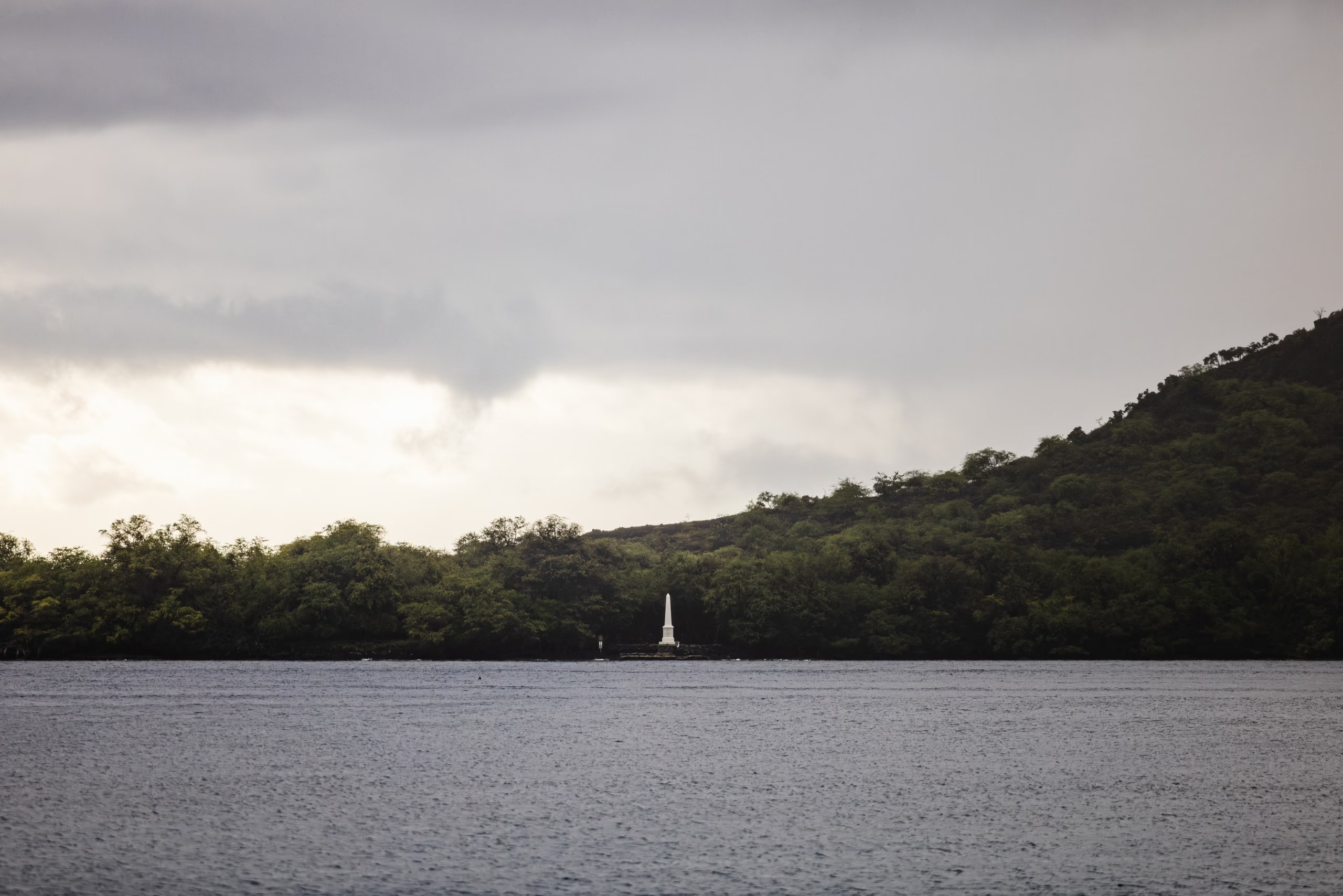
The obelisk is twenty-seven feet of white stone, and it stands on a shelf of black lava at the northern end of Kealakekua Bay. Two cannons lie chained to the rock beside it, pickled green with salt. Behind, the cliff climbs six hundred feet in a single dark sheet.
You get here by boat or by a steep and dusty trail, and either way you end up standing on ground that has been a royal capital, a temple precinct, a battleground and a grave. Two things catch most visitors off guard. The first is that this small square of rock is technically British soil. The second is that the bay was already sacred and already political long before any European ship came over the horizon.
I have swum this shoreline more times than I can count, and I still get a small lurch in the chest when I climb out at Kaʻawaloa and look up at that monument. Old Faithful, my ancient snorkel mask, fogs up on cue. The water goes flat and glassy. Then the tour boats arrive and the twentieth century catches up with you.
This page is about the history, not the reef. For the practical stuff about fins, entry points and currents, the snorkelling hub does that job properly. For the trail, the parking and the boat permits, go to getting to Kealakekua Bay.
First, the name: “the pathway of the god”
Kealakekua. Say it aloud: kay-ah-lah-kay-KOO-ah. Four beats, with the stress landing hard on the second-to-last syllable. The name breaks down as ke ala ke kua, usually translated as “the pathway of the god.” It is not decorative.
What the name describes is a route. Lono, the deity associated with rain, harvest and peace, was understood to arrive from the sea during the Makahiki season, travel inland, circle the island, and return. The bay sat on that path. Geography here functioned as liturgy, and the shape of the coastline told you where you were in the year.
Three traditional land divisions meet in this one bay. Kaʻawaloa, on the north shore, held the royal and priestly ground. Kealakekua and Nāpōʻopoʻo, to the south and east, held the residential and farming land. Each ahupuaʻa ran from the mountain ridge down to the reef, and each carried its own obligations to the aliʻi. A Polynesian navigator looking at this bay saw boundaries, names and protocol. Not scenery.
Before any ship arrived: a royal capital and four months of peace
For centuries, Kealakekua operated as an administrative and religious seat for the ruling chiefs of Hawaiʻi Island. It was not a fishing village with a nice view. It was a capital, with a tax system, a priestly class, a calendar and a legal code built on the kapu system.
Then came the Makahiki, a festival lasting roughly four months, from around October into February. The season belonged to Lono. Warfare was kapu. So was most heavy labour. Communities gathered, paid tribute, feasted, danced and competed at sport. The whole island reorganised itself around a period of arrival and rest. At the end of it, authority shifted back to Kū, the god of war, and normal politics resumed.
Hold that rhythm in your head. It is the hinge on which the entire story of 1779 turns, and almost nobody on a snorkel boat mentions it. The Bishop Museum in Honolulu holds the deepest collections on Hawaiian chiefly history if you want to read further.
A sacred landscape: Hikiau Heiau and the cliffs of Keōua
Two structures matter more than the obelisk does, and both of them are easy to walk past. See them first, before you photograph the monument, because they explain what the monument is sitting on.
Hikiau Heiau
A luakini platform roughly sixteen feet high, two hundred and fifty feet long and a hundred feet wide, sitting at the end of Nāpōʻopoʻo Road. Luakini heiau were state temples, dedicated to sovereignty, war and the legitimacy of the ruling chief. Hikiau was where the island’s political order was ritually anchored. Walk to it. Do not climb on it. Offer nothing and remove nothing, and give the ground the two minutes of quiet it has earned over several centuries.
Pali Kapu o Keōua
The six-hundred-foot precipice on the north side, named for Keōua Nui, father of Kamehameha I. Behind the cliff face sit ana huna, lava-tube burial vaults where the bones of high chiefs were lowered at night on sennit cord to protect their mana from disturbance. You can see the cave mouths from the water. You cannot land there. Ever. That is not a suggestion from a signboard; it is an absolute cultural prohibition.
The correct way to look at both is from the water, with your engine off or your paddle resting. Drift, look up, then move on. It is the same courtesy you would extend to a churchyard.
17 January 1779: two ships, in the wrong season to be ordinary
HMS Resolution and HMS Discovery stood into the bay under the command of Captain James Cook, fresh from an unsuccessful push at the Northwest Passage. They were short of water, short of fresh food, and in need of a repair anchorage.
The timing was extraordinary. Makahiki was underway. The ships arrived with square-rigged masts, yards and rigging that echoed the ceremonial emblems carried in Lono’s procession, and they came from the sea along the god’s pathway, in the god’s season. Priests and chiefs read the arrival inside their own framework, because that is what literate people do with events.
High priests took Cook ashore and escorted him up to Hikiau Heiau, where he was given red kapa and a place in the ritual. A British navigator was being made legible inside a Hawaiian political system. That, not a cartoon of mistaken divinity, is the actual event.
| Date | Event | Why it matters |
|---|---|---|
| Pre-1779 | Kealakekua serves as a royal and religious seat | Kaʻawaloa holds the chiefly and priestly ground; the bay is a capital, not a village |
| Oct to Feb | Four-month Makahiki season for Lono | Warfare and heavy labour are kapu; authority sits with Lono |
| 17 January 1779 | Resolution and Discovery anchor in the bay | Arrival coincides with Makahiki and with Lono’s ceremonial emblems |
| Late January 1779 | Cook escorted to Hikiau Heiau in red kapa | Priestly sponsorship places him inside Hawaiian ritual and politics |
| 1 February 1779 | Death of William Watman; buried at Hikiau Heiau the following day | First recorded Christian burial service on Hawaiian soil, by Hawaiian consent |
| 4 February 1779 | Ships depart | The welcome window is still open |
| 11 February 1779 | Ships return after storm damage off Kohala | Makahiki has ended; authority returns to Kū; the mood turns |
| 14 February 1779 | Confrontation at Kaʻawaloa | Cook and four Royal Marines are killed; Hawaiians die as well |
| 21 February 1779 | Remains returned and buried at sea in the bay | The crew’s own funeral rites close the episode in the same water |
| 1824 | Missionaries settle at Kaʻawaloa | A second religious order arrives on the same shoreline |
| 1874 | The obelisk is erected | Royal Navy monument assembled at the shoreline |
| 1877 | Land at Kaʻawaloa ceded to Great Britain | Small parcel becomes British territory inside the Kingdom of Hawaiʻi |
The Lono question, handled honestly
The shorthand you will hear on a tour boat is that the Hawaiians thought Cook was a god. It is partly true and mostly lazy, and you deserve better for the price of a boat ticket.
Hawaiian society was not naïve. Chiefs and priests ran a state. When they treated Cook with extraordinary honour, they were making an argument: placing him within the Lono cycle was a way of managing a strange and heavily armed arrival. Priestly sponsorship gave particular lineages a claim on the visitors and their iron, their trade goods and their firepower. Chiefly politics around Kalaniʻōpuʻu, the ruling aliʻi nui, shaped every day of the fortnight that followed.
Cook, meanwhile, wanted water, food and a repair yard. He got a religious procession. The mismatch of expectations ran in both directions and it never resolved. The Captain Cook Memorial Museum in Whitby holds the European side of that correspondence; the Hawaiian side is documented in the Royal Museums Greenwich collections and, better, in Hawaiian-language sources.
The bay is not a memorial to a single man. It is a record of one season in which hospitality, protocol and power all ran out at exactly the same time.
28 January 1779: the burial of William Watman
William Watman, quartermaster’s assistant aboard the Resolution, suffered a stroke and died. He was somebody’s mate, presumably, with a wife somewhere in England and a rating rather than a title.
Hawaiian priests gave permission for him to be buried inside Hikiau Heiau, and he was interred there with the Church of England service. It was the first recorded Christian burial on Hawaiian soil, and it happened inside a Hawaiian temple, at Hawaiian invitation, in a Hawaiian season. Quietest and most telling detail of the whole fortnight, and almost nobody mentions it.
4 February: departure. 11 February: return.
Cook sailed out on 4 February. Then a storm off Kohala snapped the Resolution‘s foremast, and there was only one sensible anchorage to repair it. The ships stood back into Kealakekua Bay on 11 February.
Everything had changed. Makahiki was over. Authority had returned to Kū, and with it the war god’s protocols, the chiefs’ harder accounting, and a growing resentment at a party of foreigners eating through local stores. Temple fencing was taken for firewood. Small frictions mounted daily. The welcome window had closed, and both sides knew it.
14 February 1779: what happened at Kaʻawaloa
On the morning of 14 February, the Discovery‘s cutter was taken from its mooring. Cook responded with an armed party and a plan to hold Kalaniʻōpuʻu aboard ship until the boat came back. It was a tactic he had used successfully elsewhere in Polynesia.
It failed here. Word travelled along the flats, a large crowd gathered, and shots were fired at the far end of the cove. Cook was struck at the water’s edge, in the shallows, and died there. Four Royal Marines died with him. Hawaiians died as well. This was not a single act of savagery or a single act of heroism; it was a collision that had been building for weeks, and both sides contributed to it.
There is no glory in the detail, and no pantomime villain either. A navigator who had spent three voyages mapping the Pacific died in knee-deep water while trying to take a sovereign hostage. An island kingdom that had extended two weeks of hospitality defended its king. I would ask you, when you stand on that lava bench, not to turn it into a story with only one hero.
Stand at the monument, then turn round and look at the cliff. That is the correct order of attention. The cliff was here first, and it is still holding the more important history.
Aftermath: the remains, the reprisals and the Hawaiian reckoning
Cook’s body was carried inland. His bones were distributed according to Hawaiian custom for high-status figures, and some were later returned to the crew, who buried what they received at sea in the bay on 21 February. I will leave the precise transaction to the historians linked above. It deserves better than a sentence on a travel page, and I am not going to pretend to a certainty I do not have.
British reprisals were immediate. Houses and settlements along the shore were burned, and the goodwill of January was gone for good. But the more consequential aftermath was Hawaiian. The chiefs had to absorb what had just happened, and what it implied about the world arriving at their door.
Within a decade, Kamehameha I was using European weapons, European advisors and European tactics to unify the archipelago under his own rule. The bay’s era as a royal capital faded as power and trade moved to Honolulu. What remained was the ground, the heiau, the burial cliffs, and the story.
1824 to 1877: missionaries, Kapiʻolani, and a British parcel
Missionaries arrived at Kaʻawaloa in 1824 and built on the flats. Christianity took hold quickly among the aliʻi, and the old kapu system had already collapsed. That same year, the high chiefess Kapiʻolani made her famous descent into Halemaʻumaʻu at Kīlauea and ate the ʻōhelo berries in front of Pele’s crater, demonstrating the new faith’s power in the most public way available to her. Different site, same upheaval, and the same generation.
Half a century later, the British arrived in a different capacity. The obelisk was erected in 1874, shipped out and assembled by the Royal Navy. Three years later, in 1877, the British government was granted a small parcel of land at Kaʻawaloa, and it holds it to this day. A Union flag does occasionally fly over Hawaiian rock. The British maintain the monument, which is why it is so much cleaner than the trail that leads to it.
If you want the visitor-facing side of the state park, the
Crowds follow the commercial schedule, not the sun. The sixty-foot catamarans leave Keauhou Bay between 8:30 and 9:00 AM and moor in Kaʻawaloa Cove around 9:15 to 9:30 AM, followed almost immediately by rigid inflatables and guided kayak groups. Between 9:45 AM and 12:30 PM you may share the cove with a hundred to two hundred snorkellers. The quieter second window runs from roughly 1:00 PM to 3:30 PM, once the morning cruises leave, though the afternoon Kona breeze brings light chop and drops visibility to forty or fifty feet. By water, the rules tighten considerably. Every vessel, kayak, paddleboard and inflatable needs a DLNR Vessel Special Use Permit. Only three licensed operators may actually land at Kaʻawaloa Flats. Rental kayakers stay in the water, tethered to their craft. The Nāpōʻopoʻo wharf is not a launch ramp, and the man in the pickup truck offering cash kayak hire is not a licensed outfitter, whatever he tells you. DOCARE officers patrol and issue citations. Before you book anything on the water, read the visitor rules and guidelines and check kayaking and boat access. Geography, before you go. The village of Captain Cook sits up on Highway 11; Kealakekua Bay is down the hill. Same area, different places, and confusing them is the single most common mix-up visitors make. If you want a boat to do the work, morning catamaran and Zodiac runs to the monument start around €92 (~$99) for a two-and-a-half hour snorkel, while the three-hour historical dinner cruise comes in at about €175 (~$189) with a narrator aboard. Compare the options on the tickets and tours page, and check best time and weather before you fix a date. Put your mask on your forehead and stop swimming for a minute. Look back at the lava bench, the white obelisk, the cliff with its buried chiefs, the heiau on the southern point. The water here is so clear it is like looking through gin, and the reef below you is older than every ship that ever anchored in this bay. The bay does not ask you to mourn. It asks you to arrive informed, behave with some restraint, and let the place lead. Plan the rest of your day with the planning hub, check the main Kealakekua Bay guide for logistics, and if you only have one question about permits or snorkelling without a guide, the FAQ page answers it in a sentence.
The last thing to do before you leave